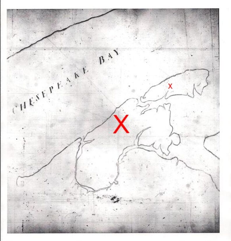
The map here on the right was completed by William Kitten (or Killen?) and John Emory on July 1, 1751 and depicts Taylors Island (Large X) and James Island (smaller x). This is a photocopy of a portion of the original map taken from microfilm. The microfilm and the original map are housed at the Maryland Historical Society in the Calvert Papers Collection. (https://www.mdhs.org/sites/default/files/calvert%20guide%20final-ron.pdf)
Transpeninsular Line:
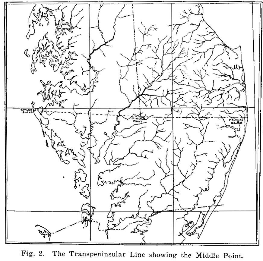
In 1751, a line was surveyed straight across the Delmarva Peninsula beginning at Fenwick Island, Delaware and continuing to Taylors Island, Maryland (east to west) to attempt to settle a boundary dispute between the William Penn family of Pennsylvania and the Lords Calvert & Baltimore of Maryland. Later in 1763 Charles Mason and Jeremiah Dixon (of Mason–Dixon line fame) used the the line, which came to be known as the Transpeninsular Line as a basis to start the calculations for the north & south Mason-Dixon Line.
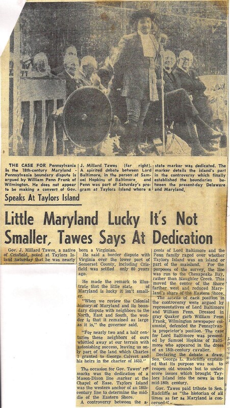
The Mason-Dixon Line is enduring testimony to the long continued, and at times acrimonious, controversy between the Lords Baltimore and the William Penn family over the determination of boundary lines between the colonies of Maryland and Pennsylvania, and also between Maryland and what is now the State of Delaware. This controversy was dramatic in nature and highly momentous in result. Large areas of territory were involved in these disputes before the Mason-Dixon Line, which is the most famous State boundary line in the United States, was finally agreed upon prior to the Revolutionary War. The far reaching nature of this controversy is evidenced by the fact that had Lord Baltimore's contention been sustained as to what should be the correct boundary line, a large portion of Pennsylvania, including the site of the City of Philadelphia, would today be part of the State of Maryland.
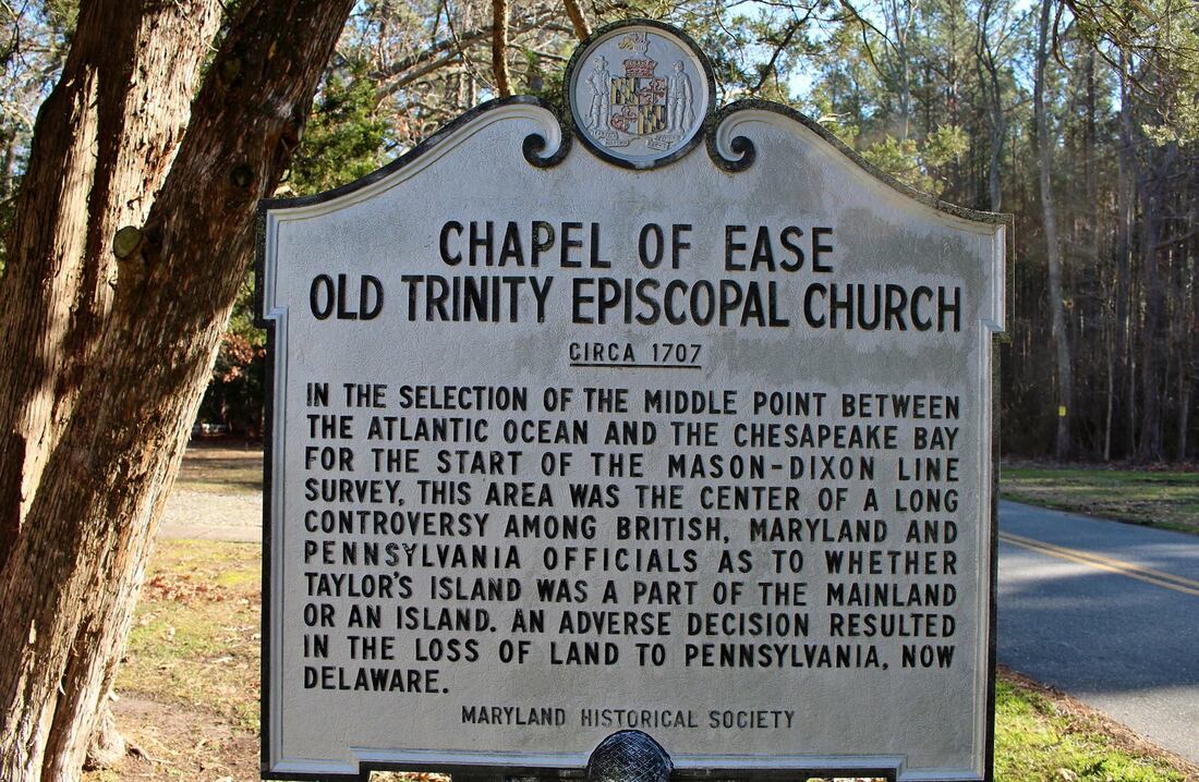
As part of the larger controversy, there was also a long and protracted difference of opinion over the selection of the "Middle Point", now called "The Middle Stone", between the Chesapeake Bay and the Atlantic Ocean for the purpose of determining the southwest corner of what is now the State of Delaware. In this dispute, the Penn family claimed that Taylor's Island in Dorchester County and the waters between Taylor's Island and the mainland of the Eastern Shore should be considered as a portion of the mainland. In the course of that controversy, a large map, the original of which is now in the possession of the Maryland Historical Society, showed clearly that Taylor's Island actually was an island. This map was prepared in the year 1751 by Lord Baltimore and the Penn family.*
If that controversy had been settled favorably to Lord Baltimore's claim, the boundary line between the States of Maryland and Delaware would today be approximately two miles to the east of its present location.
Concerning the Transpeninsular Line it took the surveyors three days to cross Taylors Island, which was about three miles wide. There are no known existing markers that are verified to have been used by the surveyors in 1751. Some old time locals have said that there was a marker near the Slaughter Creek Marina that, due to erosion, now lies near a pile of old bricks in the Slaughter Creek. Pat Neild found a granite marker near the Bethlehem "Brick" Church. This marker is about two feet tall. It was directly in line with the Transpeninsular Line and the location of the purported marker on the bottom of Slaughter Creek. Others have researched the issue and believe that the surveyors did not use markers intended to be permanent. Mason & Dixon are not believed to have traveled to Taylors Island in the 1760's.
If this issue interests you - please check back in the coming months as the Transpeninsular Line is in the process of being researched.
* Maryland General Assembly, January 2, 1957 - April 1, 1957Session Laws - Volume 640; folio 1627 No. 17 (Senate Joint Resolution 30)
Approved April 10, 1957.
With research done by T. Aaron Horner at the Nabb Research Center, Salisbury University
In 1751, a line was surveyed straight across the Delmarva Peninsula beginning at Fenwick Island, Delaware and continuing to Taylors Island, Maryland (east to west) to attempt to settle a boundary dispute between the William Penn family of Pennsylvania and the Lords Calvert & Baltimore of Maryland. Later in 1763 Charles Mason and Jeremiah Dixon (of Mason–Dixon line fame) used the the line, which came to be known as the Transpeninsular Line as a basis to start the calculations for the north & south Mason-Dixon Line.
The Mason-Dixon Line is enduring testimony to the long continued, and at times acrimonious, controversy between the Lords Baltimore and the William Penn family over the determination of boundary lines between the colonies of Maryland and Pennsylvania, and also between Maryland and what is now the State of Delaware. This controversy was dramatic in nature and highly momentous in result. Large areas of territory were involved in these disputes before the Mason-Dixon Line, which is the most famous State boundary line in the United States, was finally agreed upon prior to the Revolutionary War. The far reaching nature of this controversy is evidenced by the fact that had Lord Baltimore's contention been sustained as to what should be the correct boundary line, a large portion of Pennsylvania, including the site of the City of Philadelphia, would today be part of the State of Maryland.
As part of the larger controversy, there was also a long and protracted difference of opinion over the selection of the "Middle Point", now called "The Middle Stone", between the Chesapeake Bay and the Atlantic Ocean for the purpose of determining the southwest corner of what is now the State of Delaware. In this dispute, the Penn family claimed that Taylor's Island in Dorchester County and the waters between Taylor's Island and the mainland of the Eastern Shore should be considered as a portion of the mainland. In the course of that controversy, a large map, the original of which is now in the possession of the Maryland Historical Society, showed clearly that Taylor's Island actually was an island. This map was prepared in the year 1751 by Lord Baltimore and the Penn family.*
If that controversy had been settled favorably to Lord Baltimore's claim, the boundary line between the States of Maryland and Delaware would today be approximately two miles to the east of its present location.
Concerning the Transpeninsular Line it took the surveyors three days to cross Taylors Island, which was about three miles wide. There are no known existing markers that are verified to have been used by the surveyors in 1751. Some old time locals have said that there was a marker near the Slaughter Creek Marina that, due to erosion, now lies near a pile of old bricks in the Slaughter Creek. Pat Neild found a granite marker near the Bethlehem "Brick" Church. This marker is about two feet tall. It was directly in line with the Transpeninsular Line and the location of the purported marker on the bottom of Slaughter Creek. Others have researched the issue and believe that the surveyors did not use markers intended to be permanent. Mason & Dixon are not believed to have traveled to Taylors Island in the 1760's.
If this issue interests you - please check back in the coming months as the Transpeninsular Line is in the process of being researched.
* Maryland General Assembly, January 2, 1957 - April 1, 1957Session Laws - Volume 640; folio 1627 No. 17 (Senate Joint Resolution 30)
Approved April 10, 1957.
With research done by T. Aaron Horner at the Nabb Research Center, Salisbury University
Below is an excerpt from "Mason and Dixon's Line" a transcript of an address delivered by John H.B. Latrobe to the Historical Society of Pennsylvania on November 8, 1854.
Below is an excerpt from "The History of Boundary Dispute Between the Penns and the Baltimores Resulting in the Original Mason and Dixon Line" by Edward Bennett Matthews
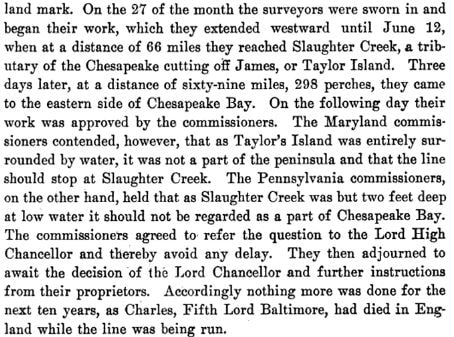
The above granite marker was found by Pat Neild near the Bethlehem "Brick" Church. At least one local historian believes that it may be a Transpinensular Line Marker or was a replacement for a non-permanent marker left by the 1751 surveyors.
